Past Human Errors to Blame for Russian Peat Fires - New York Times
Interesting, I did not realize that peat fires were such a big deal, or that they could burn underground ('subterranean conflagrations'). It is mentioned briefly in this article that when these are burning, they have a much larger effect globally than a regular flame fire. When peat burns, it releases the massive amounts of Carbon stored in that peat immediately. If all of the carbon stored in peat was released through burning, the amount of carbon in the atmosphere right now would immediately double and majorly intensify the greenhouse effect.
Thursday, August 12, 2010
Thursday, July 29, 2010
Pictures from Churchill: Plovers and scenery
 |
| Fireweed. |
 |
| Baby semipalmated plover! |
 |
| The dad - doing his broken wing dance to distract us away from the babies. |
 |
| Last egg. Most of these plovers have 4 eggs per nest. This nest had 3, and 2 had hatched this day. |
 |
| Its eyes were already opening and it had full feathers. Hearty creatures, eh? |
 |
| The 2 hatched babies. |
 | ||
 |
| The dad sitting on the eggs. The parents share babysitting duties. |
 |
| A forested area where there has been 2 fires in the past 20 years. You can see the dead trees still there and taller than the rest of the new trees and shrubs. |
More pictures: The Churchill Northern Studies Centre
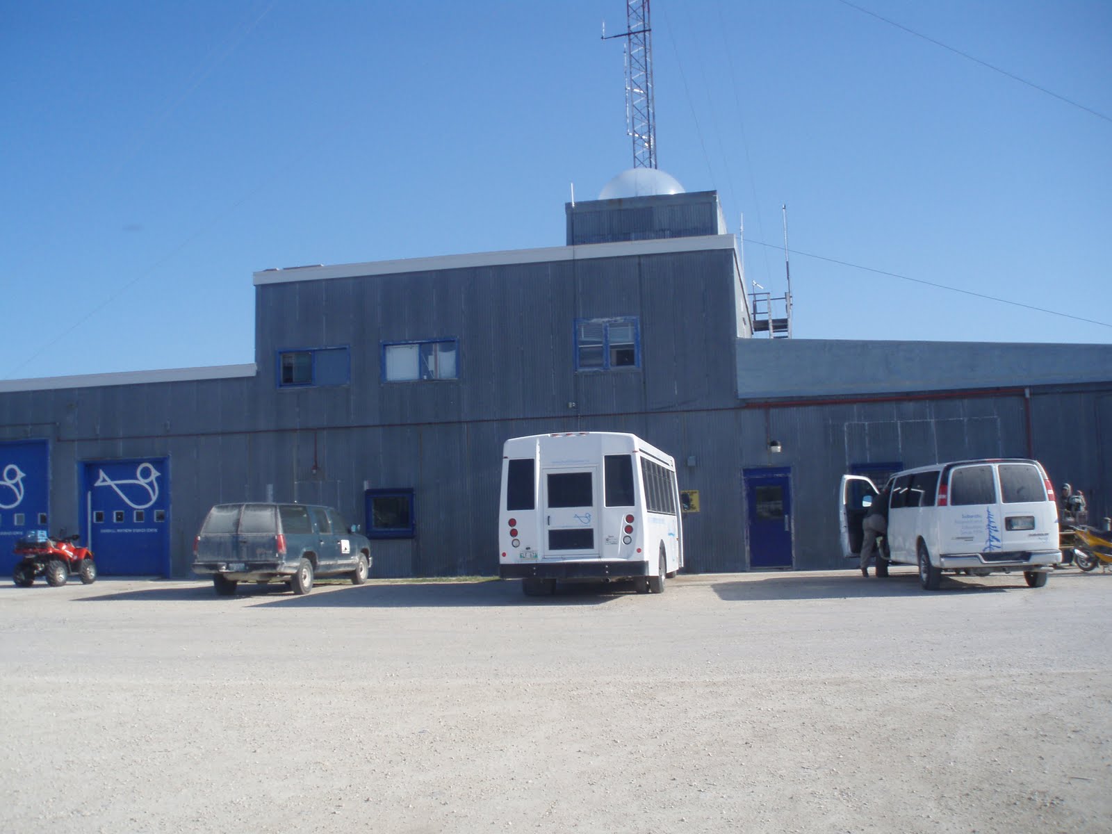 |
| The outside of the research station. You can see the Aurora Borealis viewing station on top. |
 |
| Near the station. |
 |
| Add caption |
 |
| Silver the dog. |
 |
| The cafeteria that served us such delicious food. |
 |
| Like my German jumpsuit? |
 |
| The lab. |
 |
| More of the lab. |
Wednesday, July 28, 2010
Pictures from Churchill: Field workin it
 |
| Sphagnum. This was the first time that we saw it in Churchill. |
 |
| The last, forested site. Kinda pretty minus the millions of mosquitoes |
 |
| A Sphagnum core from the forested site. You can see how it gets more and more densely packed and humified the further into the core you go. |
 |
| The transect laid down for our main site |
 |
| Glen and James working on coring through permafrost with the Russian Auger... This was seconds before it broke. |
 |
| A core in the "Bog Beaver" or active layer corer. You can see that the bottom of the core is lighter soil/sand. There are shell fragments preserved in the bottom layer. This means that there is a marine layer underlying the peat. Before this area was a peatland it was under water. |
 |
| Peat close up. Exciting eh? |
 |
| Picture of the landscape around the peatland. |
 |
| Oh yeah, exciting field shot. |
 |
| The Bog Beaver at work. |
 |
| Close up of the Bog Beaver. |
 |
| The GPR! |
 |
| So excited I got it to work! |
 |
| Taking surface samples. Measuring pH and depth to water table and cutting out the peat. |
 |
| The lake near where we took surface samples. |
 |
| The new and improved (and working) auger. |
 |
| The working permafrost corer. I got to work the drill, oh yeah. |
 |
| Permafrost core. You can see some solid ice in the bottom of it. |
 |
| close up of the core. |
Monday, July 26, 2010
Pictures from Churchill: Days 1 and 2
 |
| Polar bear skin - this was on display at the Churchill airport... the head was about 3X the size of mine. Pretty intimidating |
 |
| The first peatland I saw. The white stuff is lichen top, underneath is live peat moss. It feels squishy to step on. |
 |
| Peat up close - the pink plant is a live vascular plant (not part of the peat moss). |
 |
| Glen, James, and LeeAnn (the director of the center) walking along the peat. As you can see, the peat here was unusually dry. |
 |
| All of the trees in the area only have branches on one side. This was because of the intense wind coming off of the Hudson Bay. In the winter, this wind blows small ice particles that bounce along the snow and continuously hit the trees, making it difficult for any branches to grow on that side. The trees have a skirt of branches all along the bottom (seen here). These branches are protected from the wind during the winter because they are underneath the snow layer. |
 |
| A rocket left over from when the station here was used for launching rockets to collect atmospheric data back in the 60's. The shells were everywhere in the surrounding lakes and bogs still! |
 |
| A good picture of the landscape! Peat bog in front, then scattered black and white spruce, and the science station in the background. We were right on the Arctic treeline, which is why the trees are not continuous in the area. |
 |
| Another landscape picture. Pretty eh? |
 |
| The flower in front (only in half-bloom here) is known as fireweed. It was bright purple and everywhere. |
 |
| This was my favorite area. There were these large, flat rocks between the road to town and the bay. The bay used to reach much further inland than it is now, so all of this used to be under water. |
 |
| The Hudson Bay |
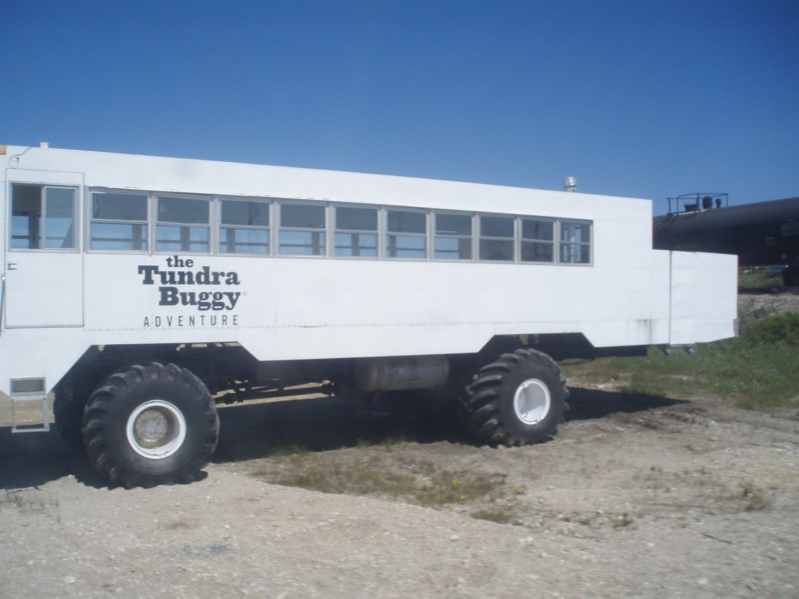 |
| Self explanatory... we did not take one of these out, but in the fall the polar bear tourist season is huge here. They take these out (they only travel about 2miles an hour) and polar bears jump on them so that tourists can see them close up. |
 |
| Caribou! |
 |
| Wikipedia aerial view picture of the Prince of Wales Fort. This fort used to be used in the Hudson Bay Trading Company days as a trading post. It was also used as a protective fort against the French. |
 |
| Outside view of the fort and several old cannons |
 |
| Inside the fort |
 |
| Looking out onto the bay. Any polar bears coming in? |
 |
| Unfortunately this is the best polar bear shot that I got. My camera does not have very much zoom. However, there is a small white dot towards the closer part of the rocky island which is a sleeping polar bear, The other two that I saw here are on the left side of the island. They were walking around so easy to see with binoculars but not quite in this picture! |
 |
| The dots on the wall of the fort are lichen. Lichen can be used as a dating technique to indicate how old the wall is/ when this pat of the fort was built. It is a radial dating technique which means that you basically measure the radius of the largest lichen here in order to indicate how old it is. |
 |
| This may be my favorite picture of the trip. Fireweed, hedysarum, and dandilions with the bay in the background. |
Subscribe to:
Posts (Atom)